But as I considered the location of South Seattle Community College, I became interested in a much more tangible kind of access—physical, pedestrian access to the campus and to neighboring landmarks such as the Duwamish Cultural Center—or the lack thereof. Some research into the history and politics of place reveals how democratic participation and geographic location can be deeply imbricated.
South Seattle Community College (SSC) sits just north of the Riverside neighborhood in West Seattle. As a new Mellon Fellow for Reaching New Publics in Community Colleges, I rode my bike to SSC to attend Larry Cushnie’s American Government class last fall, and realized I’d been there before. SSC also abuts the West Seattle Greenbelt, one of Seattle’s largest and wildest greenbelts spanning over four miles from north to south along the west bank of the Duwamish River. The summer prior, I’d scoped out a faint and overgrown trail that winds along much of its length. Two things struck me then. There are very few (that is, there are no) trails traversing the width of the greenbelt—from the hilltop to the river—and in particular, there is no trail connecting the Duwamish cultural center to the greenbelt that bears the tribe’s name.
When Sofia Huerter and I applied for a Mellon collaborative fellowship, one of our central goals was to explore what it meant to be an “access-oriented” institution. We were particularly interested in thinking about community colleges as access points for political participation, practiced through democratic deliberation in the classroom. But as I considered the location of South Seattle Community College, I became interested in a much more tangible kind of access—physical, pedestrian access to the campus and to neighboring landmarks such as the Duwamish Cultural Center—or the lack thereof. Some research into the history and politics of place reveals how democratic participation and geographic location can be deeply imbricated.
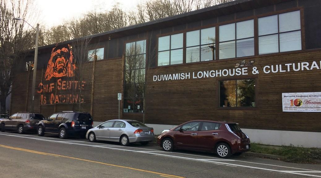
In 1855 Chief Seattle of the Duwamish tribe signed the Treaty of Point Elliott, which (at least in the eyes of the U.S. government) ceded the tribe’s ancestral land—now the City of Seattle—to the U.S. The Duwamish were never given a reservation, and, in part because of this, have never been granted federal recognition. For 150 years, the tribe has fought for a sense of cultural cohesion against the current of an indifferent and hostile settler government. The Duwamish Longhouse and Cultural Center occupies less than an acre of city land. It was purchased by the tribe in the mid-90s with some help from the city and a local philanthropist. The cultural center lies on the west bank of the Duwamish River—near the historic location of an ancestral village that has since been heavily polluted and is now a designated Superfund site. Inside the building, exhibits display the tribe’s continued connection with the land and the species that sustain their way of life, in stark juxtaposition to the straightened, concretized, and polluted stretches of the Duwamish just outside.
This last fact sheds light on the lack of east-west trails through the greenbelt. For most of the 20th century, West Seattle has been a residential zone, and the west bank of the Duwamish an industrial zone. Thus residents of West Seattle have often sought the preservation of this green space as a buffer between the pollution and noise of the industrial sector and the quiet, green neighborhoods directly west of it. Despite its conception as a buffer space, the idea of access through the greenbelt isn’t new. Rumor has it that in the early 1900s, a cog rail wended its way from the shoreline up the hill to Riverside. In the 1950s, the city contemplated cutting a highway through the south end of the greenbelt, in part to provide easy car access to SSC, plans for which were in the works (SSC opened in 1970). But most pertinently for the purposes of this post, a group of West Seattle residents and SSC professors have been plotting a trail that would connect the campus to the Longhouse for a number of years now. For proponents, the trail would encourage settler inhabitants to recognize histories and legacies of colonial violence, and instill a wider cultural memory of the land’s original inhabitants in spite of ongoing injustices. The Duwamish Cultural Center staff with whom I spoke on a recent visit offered an additional, seemingly incontrovertible argument for the trail—the center lacks any safe pedestrian access to the Longhouse, which sits along a treacherous road in what is still a predominantly industrial zone.
However, democratic city planning is complicated by many competing priorities and agendas. An original plan for a trail system through the greenbelt found momentum and backing from the Delridge Neighborhood Council—one of Seattle’s city neighborhood councils. These neighborhood councils were intended to provide the Seattle City Council with direct input from specific locales. However, they were dismantled in 2017, in part because that they were seen by many as increasingly unrepresentative of neighborhood demographics. The NIMBY agenda of many neighborhood councils was also at odds with the city’s need to address a growing housing and affordability crisis. An independent coalition (the West Duwamish Trails Group) currently advances the creation of a trail that connects the two learning centers—the Duwamish Cultural Center and South Seattle Community College. But the proposed trail remains off the docket for the city’s park and open space plans for 2017-2023. Those plans have prioritized ADA accessibility and walkability to (rather than through) greenspaces, existing as a reprieve from the urban environment.
In some ways, then, the possibility of the trail exists because of past democratic formations that have become increasingly non-representative and obsolete. And the creation of the trail has been stymied by—if not identical, then definitely resonant—commitments to accessibility and environmental sustainability that likewise warrant it. In my mind, though, these complications show the trail to be an even better potential object-lesson in the entanglements of democracy and geography than educators and curators have already articulated in advancing its establishment.
In his classroom, Larry Cushnie spends the first week discussing the history and contemporaneity of America’s native inhabitants. He has his students read an article about NDAPL and the protests of the Sioux against the continued encroachment of industrial infrastructure on sacred land. What might walking access through the greenspace add to this lesson? How might it help students imagine how different groups are presently affected by the legacies of colonial expropriation and violence? How might its development and maintenance through mutual collaboration between SSC and the Duwamish reinstate democratic participation that is rooted to the land--but in ways other than through home-ownership? What does democratic participation in and through place look like? A trail between SSC and the Duwamish Cultural Center would strengthen connections between two important cultural institutions, but also between the histories they preserve and relay and the present moment. And the possibility of an informed present is that it might yield new paths, new relations.
Justin Lawson (he/him/his)

Justin Lawson was a 2019 Mellon Collaborative Fellow for Reaching New Publics with Sofia Huerter.